Fernando de Noronha
| Native name: Arquipélago de Fernando de Noronha | |
|---|---|
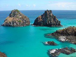
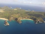 Sancho Bay and Dois Irmãos Island |
|
 |
|
| Geography | |
| Location | Atlantic Ocean |
| Archipelago | Arquipélago de Fernando de Noronha |
| Total islands | 21 |
| Major islands | Fernando de Noronha; Ilha Rata; Ilha do Meio; Ilha Sela Gineta; Ilha Rasa |
| Area | 26 km2 (10 sq mi)[1] |
| Length | 10 km (6 mi) (Fernando de Noronha Island) |
| Width | 3.5 km (2.17 mi) (Fernando de Noronha Island) |
| Highest elevation | 323 m (1,060 ft) |
| Highest point | Morro do Pico[2] |
| Country | |
| Region | Northeast |
| State | Pernambuco |
| Largest city | Vila dos Remedios |
| Demographics | |
| Population | 3,012 (as of 2009) |
| Additional information | |
| Official website | www.noronha.pe.gov.br |
| Brazilian Atlantic Islands: Fernando de Noronha and Atol das Rocas Reserves* | |
|---|---|
| UNESCO World Heritage Site | |
 |
|
| State Party | |
| Type | Natural |
| Criteria | vii, ix, x |
| Reference | 1000 |
| Region** | Latin America and the Caribbean |
| Inscription history | |
| Inscription | 2001 (25th Session) |
| * Name as inscribed on World Heritage List. ** Region as classified by UNESCO. |
|
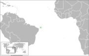
Fernando de Noronha is an archipelago of 21 islands and islets in the Atlantic Ocean, around 354 km (220 miles) offshore from the Brazilian coast. The main island has an area of 18.4 square kilometres (7.1 sq mi) and had a population of 3,108 in the year 2009[3]. The area is a special municipality (distrito estadual) of the Brazilian state of Pernambuco[4] (despite being closer to the state of Rio Grande do Norte[5]) and is also a UNESCO World Heritage Site. Its timezone is UTC−2h. The local population and travellers can get to Noronha by plane or cruise from Recife[6] (545 km) or by plane from Natal[7] (360 km). A small environmental preservation fee is charged from tourists upon arrival by Ibama (Institute of Environment and Renewable Natural Resources).
Contents |
Description
Climate
The climate is tropical, with two well-defined seasons. The rainy season lasts from March to September, the rest of the year sees little rain[8].
Geology
The islands of this archipelago are the visible parts of a range of submerged mountains. Consisting of 21 islands, islets and rocks of volcanic origin, the main island has an area of 18 km² (7.1 miles²), being 10 km (6.2 miles) long and 3.5 kilometres (2.170 mi) wide at its maximum. The base of this enormous volcanic formation is 756 m below the surface. The main island, from which the group gets its name, makes up 91% of the total area; the islands of Rata, Sela Gineta, Cabeluda and São Jose, together with the islets of Leão and Viúva make up the rest. The central upland of the main island is called the Quixaba.[9]
Flora
The island was covered in forest until the 19th century, when it was cleared to prevent prisoners on the island from building rafts. The islands are now predominantly covered by shrubs, with some areas of recently planted secondary forest. Many of the plants on the island today were introduced by people.
The United Nations Environment Programme lists 15 possible endemic plant species, including species of the genera Capparis, (2 species) Ceratosanthes (3 species), Cayaponias (2 species), Moriordica, Cereus, Palicourea, Guettarda, Bumelia, Physalis, and Ficus noronhae.[10] Combretum rupicola is also a likely endemic.
Fauna
The islands have two endemic birds — the Noronha Elaenia (Elaenia ridleyana) and the Noronha Vireo (Vireo gracilirostris). Both are present on the main island; Noronha Vireo is also present on Ilha Rata. In addition there is an endemic race of Eared Dove Zenaida auriculata noronha. An endemic sigmodontine rodent, Noronhomys vespuccii, mentioned by Amerigo Vespucci, is now extinct.[11] The islands have two endemic reptiles, Amphisbaena ridleyi and Trachylepis atlantica.[12]
Marine life
The life above and below sea is the main attraction of the island. Sea tortoises, dolphins, albatrosses and many other species are frequently observed.
History
1500-1700
Many controversies mark the discovery of the archipelago by Europeans. From its original name, Ilha da Quaresma (Lent Island), it was sighted by expeditions in the years 1501, 1502 and 1503. The Viscount of Santarém, however, attributed the discovery to Gaspar de Lemos, captain of the supply ship of Pedro Álvares Cabral's fleet, sent back to Portugal with news of the discovery of Brazil. Modern historians, however, credit the 1501-1502 expedition led by Fernão de Noronha with the discovery of the archipelago. The main island appears in the logbook of Martim Afonso de Souza, 1530 as the Ilha de Fernando de Noronha.[13]
The first to actually describe the island was Amerigo Vespucci, who traveled with a Portuguese expedition of Gonçalo Coelho to Brazil in the year 1503.
In 1534, the Fernando de Noronha Archipelago was invaded by the English, and from 1556 until 1612, it was held by the French. In 1628, it was occupied by the Dutch, who were displaced two years later by a Spanish-Portuguese military expedition led by Rui Calaza Borges. The Dutch built a fort on the site of the present ruins of the Forte de Remedios. The Dutch occupied the island once again in 1635, making it a hospital for their troops who occupied northeastern Brazil (the Brazilian coast between Rio São Francisco and Maranhão). The island became known as Pavonia, in honor of Michiel de Pauw, one of the directors of the Dutch West Indies Company. It would remain under Dutch control for nearly twenty years, when it was reconquered by Portugal. In 1654, it was the last fort the Dutch surrendered to the Portuguese, marking the end of the Dutch era in north-east Brazil.
1700-1900
Finding it uninhabited and completely abandoned in 1736, the French East Indies Company took the island and renamed it Isle Dauphine.
Only from 1737 on, after the expulsion of the French, was Fernando de Noronha definitively occupied by Portugal. This time it was decided to fortify the island. For this purpose, ten forts were built in all strategic points where a possibility of disembarkation existed; nine in the main island and one in the Ilha de São José situated in front of the Saint Anthony harbor. The forts were connected by a network of stone roads. This defense system was planned by the Portuguese military engineer Diogo da Silveira Veloso. Around 1770, the first permanent settlement, Vila dos Remédios, was founded. The village was divided in two units (pátios); in the superior one were the administrative buildings, in the lower one the church and the associated religious buildings.
As Brazil became independent in 1822, very little changed for Fernando de Noronha. In 1832, the island was visited by an expedition which included Charles Darwin. His experiences on Fernando de Noronha were recorded in his journal, later published as The Voyage of the Beagle.[14]
1900-2010
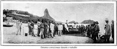
In the late 18th century, the first prisoners were sent to Fernando de Noronha. A prison was built. In 1897 the government of the state of Pernambuco took possession of the prison.[15] Between 1938 and 1945, Fernando de Noronha was a political prison. The former governor of Pernambuco, Miguel Arraes, was incarcerated there. In 1957 the prison was closed and the archipelago was visited by President Juscelino Kubitschek.[16]
At the beginning of the 20th century, the British arrived to provide technical cooperation in telegraphy (The South American Company). Later the French came with the French Cable [17] and the Italians with Italcable.[18]
In 1942, during World War II, the archipelago was made a Federal Territory that also included Rocas Atoll and Saint Peter and Paul Rocks, and political and ordinary prisoners were sent to the local prison. An airport was constructed in September 1942 by the United States Army Air Force Air Transport Command Natal-Dakar air route, which provided a transoceanic link between Brazil and French West Africa for cargo, transiting aircraft and personnel. It was transferred to the jurisdiction of the United States Navy on 5 September 1944.[19]
In 1988, approximately 70% of the archipelago was declared a maritime national park, with the goal of preserving the land and sea environment. On October 5, 1988, the Federal Territory was dissolved and added to the state of Pernambuco (except Rocas Atoll, which was added to the state of Rio Grande do Norte).
Nowadays, Fernando de Noronha's economy depends on tourism, restricted by the limitations of its delicate ecosystem. In addition to the historical interest noted above, the archipelago has been the subject of the attention of various scientists dedicated to the study of its flora, fauna, geology, etc. The jurisdiction is considered to be a separate "entity" for the DX Century Club, and so is visited rather often by amateur radio operators.
In 2001, UNESCO declared Fernando de Noronha, with Rocas Atoll, a World Heritage Site. The reasons for this were a) the island's importance as a feeding ground for several species, including tuna, billfish, cetaceans, sharks, and marine turtles, b) a high population of resident dolphins and c) protection for endangered species, such as the hawksbill turtle and various birds.[20]
Fernando de Noronha Airport is served by daily flights from Recife and Natal on the Brazilian coast.
Fernando de Noronha beaches

The main islands are the visible parts of a range of submerged mountains, islets and rocks. The Archipelago of Fernando de Noronha hosts ecological sites ideal for exuberant marine animal life, due to its geographic location far from the continent and well within the path of the Southern Equatorial Currents, as well as the nature of its climate. Noronha beaches[21] and bays include:
- Sancho beach
One of the main points for diving in Fernando de Noronha, the beach is surrounded by a natural wall which serves as a shelter for some species of seabirds. The locals, called as Sancho bay or beach.
- Conceição beach
One of the best frequented in the islands. Offers good waves, beautiful landscape and has some bars.
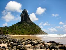
- Cacimba do Padre beach
One of the most famous of the islands, has two adjacents beaches (Americano and Bode beaches). This beach is ideal to practice surf due to its strong waves. Its part of the International and National calendar of surf every year. Also, from there is possible to see the famous Noronha postcard - Morro Dois Irmãos or two brothers rocks.
- Golfinhos bay
Which means dolphins bay. Its a bay located behind Sancho beach, and it is an area of preservation by Ibama, banned for swimming and for access by boats, serves as shelter for spinner dolphins or golfinhos rotadores. Just one trail leads to the top of a natural wall where is possible to see the spinner dolphins.
- Porcos bay
Or Pigs bay in English, is one of the main highlights of Fernando de Noronha. The bay is in front of two brothers rocks and has some natural pools formed between the rocks and reefs.
- Santo Antonio Port bay
Its located adjacent to the main port of the archipelago. Local for loading and unloading vessels with goods supplies to the islands. Also, its the starting point for the local tours and cruises to Recife. Has a small beach with calm water and a very beautiful sunset.
- Boldró beach
This beach has waters dominated by coral formation. Are ideal for scuba diving but dangerous, due to the violence of the water.
- Americano beach, Bode, Biboca, Cachorro , Do Meio, Quixaba, Ponta da Sapata, Leão, Ponta das Caracas, Sueste bay, Atalaia, Enseada da Caeira, Buraco da Raquel, Caeira and Ponta da Air France beach.
Diving
Thanks to the deep clear water surrounding the island, Fernando de Noronha is a great location for scuba diving. Warm water and exuberant subaquatic fauna and flora can be found during dives from 25 to 40 m deep. A Brazilian warship, the corvette Nael Ipiranga, sank in 1987 and is lying in pristine condition at around 60 m (190 feet).
Conservation and environmental threats
Most of the original vegetation was cut down in the 19th century, when the island was used as a prison, to keep the prisoners from hiding and making rafts.
Also, invasive species have been introduced:
- Linseed, intended for use as cattle feed.
- Tegu lizards (Tupinambis merianae, locally known as teju) introduced in the 1950s to control a rat infestation. Ironically, that didn't work out, because Tegus are diurnal and rats, nocturnal. Now the lizards themselves are considered a plague, feeding mostly on bird eggs.[22]
- Rock Cavies (Kerodon rupestris, locally known as mocó) introduced by the military in the 1960s as hunting game for soldiers.[23]
Economic indicators
| HDI (2000) | Population (2009) | GDP (2007)x1000 R$ | % PE | GDP pc R$ | Hostels/pousadas beds (2006) |
|---|---|---|---|---|---|
| 0.862 | 3.108 | 20.901 | 0.034% | 7.462 | 1.492 |
References
- ↑ Fernando de Noronha Embratur. Retrieved on 6 June 2009.
- ↑ Fernando de Noronha Dolphins Communications. Retrieved on 6 June 2009.
- ↑ [1]
- ↑ [2]
- ↑ [3]
- ↑ [4]
- ↑ [5]
- ↑ [6]
- ↑ Carlos Secchin, Clóvis Barreira e Castro, Arquipélago de Fernando de Noronha, 2nd ed. 1991.
- ↑ Fernando de Noronha, Islands of Brazil, UN System-wide Earthwatch
- ↑ Carleton, M.D. and Olson, S.L. 1999. Amerigo Vespucci and the rat of Fernando de Noronha: a new genus and species of Rodentia (Muridae, Sigmodontinae) from a volcanic island off Brazil's continental shelf. American Museum Novitates 3256:1–59.
- ↑ Mausfeld, P., Schmitz, A., Böhme, W., Misof, B., Vrcibradic, D. and Duarte, C.F. 2002. Phylogenetic affinities of Mabuya atlantica Schmidt, 1945, endemic to the Atlantic Ocean archipelago of Fernando de Noronha (Brazil): Necessity of partitioning the genus Mabuya Fitzinger, 1826 (Scincidae: Lygosominae). Zoologischer Anzeiger 241:281–293.
- ↑ Secchin and Barreira e Castro
- ↑ A Naturalist's Voyage Round the World By Charles Darwin, ISBN 1-60303-314-9 URL: http://books.google.co.uk/books?id=dhzsSTtKgygC
- ↑ Noronha História
- ↑ Fernando de Noronha: História da ilha remete ao inferno e ao paraíso
- ↑ History of the Atlantic Cable & Undersea Communications, French cable companies
- ↑ History of the Atlantic Cable & Undersea Communications, Italcable
- ↑ USAFHRA Document 00001957
- ↑ World Heritage description
- ↑ http://www.viabrturismo.com.br/fernandodenoronha/fernandodenoronha.shtml
- ↑ Tupinambis merianae, Instituto Hórus de Desenvolvimento e Conservação Ambiental (The Nature Conservancy), 2005
- ↑ Kerodon rupestris, Instituto Hórus de Desenvolvimento e Conservação Ambiental (The Nature Conservancy), 2005
- ↑ PE State site - City by city profile
External links
- (Portuguese) Official website
Tourism
- (English) A photo tour of the island
- (English) Site about islands in Brazil
- (English) Information in English about Noronha
- (English)/(German) Tourist information provided by a local resident
- (English) Fernando de Noronha-Atol das Rocas moist forests (WWF)
- (English) Audio interview with Fernando de Noronha resident about life on Fernando de Noronha
- (English) Extensive list of Fernando de Noronha pousadas bookable online
- http://www.noronha.info/
- http://www.airtrip.com.br/
- http://www.ilhadenoronha.com.br/
Videos
- Video Fernando de Noronha National Park (EN)[7]
- Video Noronha beaches and underwater [8]
- Video Noronha Surf paradise [9]
- Photo video Noronha [10]
- Video Noronha scuba diving [11]
|
|||||||||||||||||||||||
|
|||||||||||||||||||